







Walking & Hiking
Clifftop trails and riverside strolls
The best walking & hiking in Riverland
Walk the cliff tops above the Murray, loop the wetland trails at Hart Lagoon, or trace the riverfront promenades that link the Riverland’s towns.
Read our guide to walking & hiking ↓Browse walking & hiking by area
Map shows the 24 places on this page.
Berri Lookout Tower Free
View →97 steps to the best free view in Berri
A disused town water tower converted into a 15.8-metre lookout. Climb 97 steps for 360-degree views over Berri, the orchards and the winding Murray.
Berri Riverfront
View →Boardwalks, lawns and a river beach
Berri’s redeveloped riverfront precinct, with boardwalks, lawns, a swimming beach, playground and the giant Big Orange nearby.
Bert Dix Memorial Park
View →A riverside picnic spot at Paringa
A grassy riverfront reserve at Paringa beside the historic bridge, with picnic areas, a playground and river views.
Bookmark Creek Wetland Free
View →A restored wetland on the edge of Renmark with an easy walking loop and prolific birdlife.
Bookpurnong Cliffs
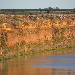
View →Ochre river cliffs above the Murray near Loxton
Border Cliffs Customs House Free
View →Where South Australia taxed the river trade
The 1884 customs house at Port Murthoo, built to collect duties from paddle steamers crossing the border. A walking trail and quiet river reach mark one of the Murray's oddest historic outposts.
Brookfield Conservation Park Free
View →The wombat reserve a Chicago zoo gave to South Australia
A 5,515-hectare conservation park west of Blanchetown, bought by the Chicago Zoological Society in 1971 to protect the southern hairy-nosed wombat and gifted to South Australia in 1977. Wombats, western grey kangaroos and mallee birds.
Gluepot Reserve $
View →An internationally significant mallee bird reserve north of the river, run by BirdLife Australia.
Hart Lagoon Free
View →A restored wetland and birdwatching site near Waikerie with an easy interpretive walking loop.
Headings Cliff Lookout
View →Big views over the river bend
A clifftop lookout high above the Murray in the Murray River National Park, with sweeping views over the floodplain.
Holder Bend Reserve Free
View →Riverside camping and walking reserve under the Waikerie cliffs, rich in birdlife.
Katarapko (Murray River National Park)
View →Canoe trails and bush camps
The Katarapko section of the Murray River National Park, laced with anabranch creeks, bush campsites and canoe trails near Berri.
Katarapko Creek Canoe Trail
View →A marked paddling trail through the red-gum creeks of Katarapko, deep in Murray River National Park.
Loch Luna Game Reserve Free
View →A maze of lagoons, creeks and reed beds near Barmera, best explored by canoe.
Loxton Riverfront & Tree of Knowledge
View →Riverside walks and flood-height history
Loxton’s leafy riverfront, home to the Tree of Knowledge marking historic flood heights and easy riverside walking trails.
Loxton Riverfront Walking Trails Free
View →A shady riverside walking trail linking Loxton's historical village and the Tree of Knowledge.
Loxton's Pepper Tree Free
View →The tree that marks where a town got its name
A gnarled old peppercorn tree on the Loxton riverbank, marking the site of the 1878 boundary rider's hut from which the town took its name.
Lyrup Flats, Murray River National Park
View →A red-gum floodplain section of Murray River National Park near Lyrup, with camping and canoeing.
Maize Island Lagoon Conservation Park
View →An island and lagoon reserve on the Murray at Waikerie
Martin Bend Reserve
View →A popular riverside reserve and wetland just downstream of Berri, with camping, walking trails and birdlife.
Moorook Game Reserve
View →A patchwork of lagoons and red gum on the Murray floodplain
Morgan Conservation Park
View →Floodplain wetlands at the river's bend
A wetland conservation park on the Murray floodplain near Morgan, rich in birdlife and laced with creeks and lagoons.
Morgan Riverfront Reserve
View →Shady riverfront lawns beneath the historic Morgan wharf, with picnic spots and river views.
Morgan Wharf
View →A grand relic of the river-trade boom
The towering timber wharf at Morgan, a monument to the days when this was one of South Australia’s busiest inland ports.
About walking & hiking in Riverland
Walking in the Riverland is mostly gentle, shady and rich in birdsong. The terrain is flat floodplain rather than mountain, so the trails here favour the easy ramble - riverfront paths under towering red gums, wetland loops alive with waterbirds, and short climbs to clifftop lookouts with views along the Murray's great bends.
Follow the creek-side loop at Bookmark Creek Wetland on the edge of Renmark, stroll the shaded Loxton riverwalk past flood markers and the famous Tree of Knowledge, or take in the ochre cliffs from Headings Cliffs Lookout.
For wilder walking, the levee tracks of Loch Luna and the floodplain reserves around Morgan reward those who like solitude. Most outings are flat and family-friendly, best tackled in the cool of the morning. Pair a walk with some wildlife watching and you'll see the Riverland at its quiet, unhurried best.
Walking & Hiking in Riverland - frequently asked questions
What is the Riverland known for when it comes to walking and hiking?
The Riverland sits on flat Murray River floodplain, so the walking here is gentle rather than mountainous - riverfront paths beneath towering red gums, wetland loops alive with waterbirds, and short climbs to clifftop lookouts over the river's great bends. Signature spots include the ochre-coloured Headings Cliffs near Paringa, the riverfront promenades at Renmark and Berri, and the trails of Murray River National Park near Berri. It is a region of easy rambles full of birdsong rather than tough summit hikes.
What is the Murray River Walk and do I need to book it?
The Murray River Walk is a guided multi-day walking journey run by Murray River Trails out of Renmark, and it is recognised as one of the Great Walks of Australia. It is a four-day, three-night experience where you walk roughly 12 to 14 kilometres a day through red gum forest, wetlands and beside the red cliffs, returning each evening to a houseboat that moves with you. It must be booked in advance, typically runs in the cooler months from around May to September, and is a premium guided tour rather than a free self-guided trail.
Where can I find the best clifftop lookout walks in the Riverland?
Headings Cliffs near Paringa, just east of Renmark, is the region's most photographed clifftop view, where red and ochre sandstone cliffs rise around 70 metres above a sweeping bend of the Murray. Parking is free and a short walk leads to a steel lookout tower with views over the Bookmark Biosphere and floodplain. Other rewarding clifftop and lookout stops include the Berri Lookout Tower, Bookpurnong Cliffs and the riverfront cliffs around Berri.
Are Riverland walking trails family and dog friendly?
Many Riverland walks are easy, flat and family friendly, including the riverfront promenades at Renmark and Berri and the shorter wetland and creek loops. Dogs are welcome on most town riverfront paths but are restricted in conservation areas - in Murray River National Park's Katarapko section, for example, dogs are only allowed on Panky's Trail and must be on a lead no longer than three metres. If you are walking with a dog, check the specific park or reserve rules first, as national parks and BirdLife reserves like Gluepot generally prohibit pets to protect native wildlife.
When is the best time of year to go walking in the Riverland?
Spring (September to November) and autumn (March to May) are the most comfortable seasons, with mild temperatures, wildflowers and very active birdlife along the wetlands and mallee. Summer is best avoided for longer walks as Riverland days often climb above 35 degrees, so if you do walk in the warmer months stick to early morning, shady riverfront paths and carry plenty of water. For birdwatching at places like Gluepot Reserve near Waikerie, the cooler months bring the most reliable sightings.